The Auckland Harbour Bridge is more than a road link. It is the fast spine between the city and the North Shore, carrying daily life over the Waitematā Harbour. In this guide you will learn what the bridge is, how it works, why it matters, and the best ways to use it—whether you drive, bus, or plan a day out on the water instead.
If you are new to the city or just want reliable answers, this page gives clear, locally grounded detail that helps you make smart choices when the auckland harbour bridge is part of your trip.
What is
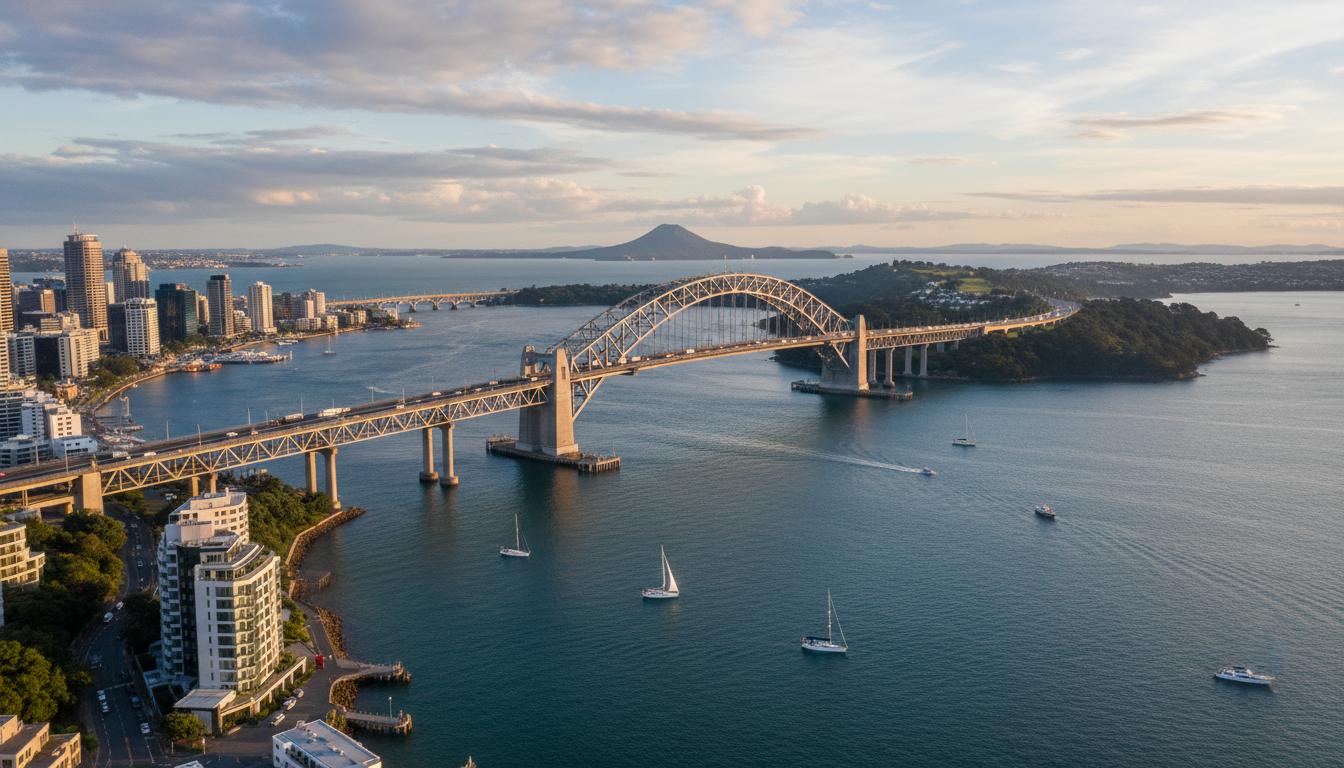
The auckland harbour bridge is an eight-lane motorway bridge on State Highway 1. It links St Marys Bay near Auckland’s city centre with Northcote Point on the North Shore, crossing the Waitematā Harbour. It opened in 1959 with four lanes and was widened in 1969 by adding “clip-on” box-girder lanes on each side to handle fast-growing demand.
The bridge is owned and operated by Waka Kotahi NZ Transport Agency. It carries private vehicles, buses, and freight. There is no public pedestrian or cycling path at present, though walking and cycling options continue to be explored as part of broader Waitematā Harbour Connections planning.
Key facts at a glance
- Location: St Marys Bay to Northcote Point, across the Waitematā Harbour
- Route: State Highway 1 (Northern Motorway)
- Lanes: 8 (4 original centre lanes plus two “Nippon clip-ons” each side added in 1969)
- Opened: 30 May 1959 (tolls removed in 1984)
- Typical speed limit: 80 km/h (lower during strong winds or works)
- Clearance above water: about 43 m at the main navigation span (varies with tide)
- Daily traffic: commonly over 170,000 vehicles on a typical weekday
- Management: Waka Kotahi NZTA (operations, maintenance, safety)
Specifications (summary)
| Attribute | Detail |
|---|---|
| Total length | Approximately 1,020 m (main spans plus approaches) |
| Main structure | Steel truss superstructure with steel box-girder “clip-ons”; reinforced concrete piers |
| Deck | Orthotropic steel deck on clip-ons; asphalt wearing surface |
| Shipping channel | Central span with vertical clearance suitable for large vessels |
| Connections | City side to CMJ via Northern Motorway; North side to Onewa Rd and Northern Corridor |
How it works
Structurally, the bridge combines a central steel truss with side spans supported by concrete piers. The 1969 “Nippon clip-ons” are steel box-girders bolted to the outside of the original structure. They added two lanes on each side, taking the bridge from four to eight lanes.
From an operations point of view, the auckland harbour bridge runs as a controlled motorway. Overhead lane signals indicate closures, speed reductions, and restrictions for high-sided vehicles during strong winds. A central median barrier separates northbound and southbound traffic. Heavy trucks are often directed to the inner lanes to reduce stress on the clip-ons.
Maintenance is continuous. Crews inspect welds, manage fatigue on the clip-on lanes, repaint steelwork, and use dehumidification in closed steel spaces to control corrosion. After severe weather or incidents, engineers assess and, if needed, temporarily restrict lanes while repairs are made. The goal is simple: keep the bridge safe and available while managing an enormous traffic load.
The approaches have evolved too. Projects like the Victoria Park Tunnel and Northern Corridor Improvements reduced bottlenecks near each end of the bridge and improved bus reliability on the Northern Busway, which runs parallel to SH1 north of the bridge.
Types / examples
Structural components you will hear about
- Original truss: The central steel framework built in the 1950s that carries the core four lanes.
- Clip-ons: Steel box-girders added in 1969 on both sides to increase capacity by four lanes. Known locally as the “Nippon clip-ons.”
- Piers and foundations: Reinforced concrete supports set into the harbour bed, designed for durability in a marine environment.
- Orthotropic deck: A stiff, lightweight steel deck on the clip-ons that spreads loads efficiently.
- Lane control system: Overhead signals and sensors that manage closures, wind warnings, and speed limits.
Everyday examples of how people use or experience the bridge
- Commuting by car between the North Shore and the city.
- Express bus services using the Northern Busway and then the auckland harbour bridge to reach the CBD.
- Ferry as an alternative route during peak congestion or when wind restrictions are in place.
- AJ Hackett’s Auckland Bridge Bungy and Bridge Climb experiences, which operate from the city-side truss (commercial tours, booked in advance).
- Harbour shipping passing under the main navigation span.
Pros and cons
Benefits
- Fast cross-harbour link: Short travel time between the CBD and the North Shore outside peak hours.
- High capacity: Eight lanes keep the city moving and support freight and emergency services.
- 24/7 access: Managed motorway operations maintain flow around the clock.
- Bus-friendly: Integrates with the Northern Busway, improving public transport travel times.
Limitations
- Congestion at peaks: Morning and evening rush hours can be heavy, especially in wet or windy weather.
- Wind sensitivity: High-sided vehicles may face restrictions; occasional lane closures for safety.
- No public footpath or cycleway: People on bikes and on foot must use ferries or other options for now.
- Ongoing maintenance: Essential works can cause off-peak closures or speed reductions.
How to use or choose
Choosing how to cross the Waitematā depends on your time, budget, and tolerance for traffic. Below is a simple framework New Zealanders can use to make the best call on any given day.
Step-by-step: Plan a smoother crossing
- Check conditions: Look at real-time updates from Waka Kotahi NZTA (traffic cameras, Twitter, or the NZTA website). Wind and incidents change things fast.
- Pick your mode: Decide between driving, bus, or ferry based on live conditions and your destination.
- Time your trip: If you can, avoid 7–9 a.m. citybound and 4–6:30 p.m. northbound. Aim for shoulders of peak.
- Use smart routing: If driving, consider on-ramps with fewer delays (e.g., Onewa Road vs Esmonde Road, depending on congestion reports).
- Follow lane guidance: Obey overhead lane signals and posted speeds. In wind, expect lower limits and restrictions.
- If you drive a heavy vehicle: Use inner lanes when directed and watch for wind advisories. Secure loads.
- Have a Plan B: If there’s a major incident, switch to a ferry from Devonport, Bayswater, or Hobsonville (depending on where you are) or delay travel.
Crossing options compared
| Option | Best for | Typical travel time | Cost | Pros | Cons |
|---|---|---|---|---|---|
| Drive over auckland harbour bridge | Door-to-door trips, off-peak travel, carrying gear | 10–20 min off-peak; 25–45+ min at peak (conditions vary) | Fuel/parking | Flexible, 24/7, links to whole motorway network | Congestion, parking costs, wind restrictions affect high-sided vehicles |
| Bus over the bridge (Northern Busway + city services) | CBD commuters and students | Often similar or faster than driving at peak | Fare | Bypasses some queues, frequent at peaks, no parking stress | Less flexible door-to-door |
| Ferry across the harbour | City–Devonport, Bayswater, Birkenhead, Hobsonville | 7–30 min depending on route and wait time | Fare | Reliable alternative during incidents, scenic, unaffected by bridge wind limits | Limited routes/timetables vs a car |
Practical tips locals use
- Watch the wind. If gusts are up, buses and cars will still run, but high-sided vehicles may be restricted. Expect slower speeds.
- Northbound Friday afternoons and pre-holiday periods are particularly busy. Plan early departures.
- If you must drive at peak, leave gaps, choose a steady lane, and avoid last-second merges near the crest.
- For city meetings, combining the Northern Busway with a short city walk is often the least stressful option.
FAQ
Is the auckland harbour bridge tolled?
No. Tolls were removed in 1984.
Can I walk or cycle across?
Not at present. There is no public pedestrian or cycle path on the bridge. Active-mode options are being considered in wider Waitematā Harbour planning.
What is the speed limit on the bridge?
Typically 80 km/h. It can be reduced during high winds, maintenance, or incidents. Always follow the posted signs and lane signals.
Why is the bridge sometimes closed to trucks?
In strong winds, high-sided vehicles are at risk of tipping. Waka Kotahi may restrict them to manage safety and structural loading.
Who operates and maintains the bridge?
Waka Kotahi NZ Transport Agency manages operations, inspections, and maintenance.
When did the clip-ons get added?
1969. The steel box-girder extensions—known as the “Nippon clip-ons”—increased the bridge from four to eight lanes.
How high is the clearance for ships?
About 43 metres under the main span at high tide, allowing large vessels to pass.
How busy is the bridge?
It is among New Zealand’s busiest roads, with daily volumes commonly over 170,000 vehicles.
What happens after a big incident or storm?
Engineers inspect affected parts, temporary restrictions may apply, and repairs are prioritised. Traffic management keeps other lanes moving where possible.
Is there bungee jumping on the bridge?
Yes. AJ Hackett operates a commercial bungy and bridge walk from the city-side truss. Bookings are required.
Are there plans for another crossing?
Work is ongoing on the Waitematā Harbour Connections programme to assess future options such as new public transport links and additional cross-harbour capacity. Decisions are being refined through business case processes.
How it fits into Auckland’s transport network
The auckland harbour bridge anchors the Northern Motorway and integrates with the Central Motorway Junction, the Northern Busway, and ferry services. This mix is what keeps the region moving when any single part is under pressure. When you plan your trip with that bigger picture in mind—mode choice, timing, and live updates—you get a smoother crossing and fewer surprises.
Whether you drive over the crest at dawn, watch the whitecaps from a ferry deck, or clip into a harness for a bungy, the bridge remains a working landmark. It is built to do a job, and it does that job every day—safely, efficiently, and with a view you never quite get used to.